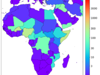
The Violence Early-Warning System (ViEWS) is a publicly available data-driven forecasting system at the frontier of research that generates monthly predictions of conflict fatalities up to 36 months ahead – throughout Africa and the Middle East. The project launched in 2017 to help policy-makers and practitioners plan anticipatory action and humanitarian interventions with a transparent and evidence-based approach. It is based at Uppsala University and Peace Research Institute Oslo.
Innovation Tag: Geolocation and Mapping
During the Russian invasion of Ukraine, relief organizations and government agencies lacked data about events on the ground and struggled to mount an effective response. New methods of event detection were urgently needed. A research team comprised of country experts and computational social scientists created a Twitter-based event detection system that provides geo-located event data on humanitarian needs, displaced persons, human rights abuses and civilian resistance in near real-time.
The Future Tech Challenge (FTC) is a pilot initiative led by DPER to connect and collaborate across the wider ecosystem, and engage in transformative innovation by experimenting with, and applying new technology to address pressing public sector problems and opportunities that deliver improved services to the public. Drive innovation using emerging technology, enhance collaboration, meet National strategic priorities, generate knowledge & learnings and develop prototyped solutions.
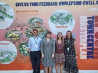
The PropTech Engagement Fund was launched in 2021 and has worked with 41 Local Authorities to date on accelerating the adoption of digital citizen engagement tools and transforming community involvement in placemaking. Our ongoing programme is the largest UK Government PropTech Programme, leading on how to work with industry, tech start ups and local governments to increase the diversity and positivity of placemaking conversations and to fast track new digital policy and local housing delivery.
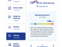
In COMo, the CO2 concentration (CO2 = Carbon Dioxide) serves as a measure for indoor air quality and aerosol pollution; the latter correlates with the potential (COVID) viral load. Objective CO2 readings via networked sensors enable operators to control the indoor air quality and thus reduce the risk of infection for visitors. Published data allow visitors to make decisions about visiting the facility.
All content is available under open source licenses (MIT, BSD, Creative Commons).
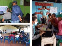
Several land areas in Colombia lack of formal registry and documents as a consequence of the absence of territorial information and the aftermath effects of the armed conflict. Through the intensive use of new technologies and innovative methodologies, the problem of characterization of vacant areas was addressed by using novel methods to consolidate land data and information, benefiting the farmers of the area.
Madrid Mobility 360' is a mobile application that allows citizens moving around the city and calculates the most efficient route between all modes of transport in the capital, both public and carsharing or bicycles. It includes a powerful route planner, which allows estimating current and future journey times, and provides the capacity on a specific bus. The app allows payment for various methods of transport and reports the CO2 emissions generated.
The $800B events industry is antiquated. Huge gaps exist between cities and events. EQ is a mobile platform that streamlines traffic, navigation, crowd control, and security in real time around crowded environments while collecting critical data and analytics. Vasta will soon unveil this next-generation suite of event and venue planning services and digital simulation platform. The EQ Platform was made for cities of any size; public safety; citizens/visitors; fans/non-fans; and for organizers.
TrueMed will change the brand protection market with modern AI based software approach for detecting originals and counterfeits around the world. TrueMed’s innovation is the next generation method for rapidly detecting goods, at any point of distribution, by customs or even consumers. It can be used by brand owners and authorities in global and cross-border collaborations. It is 100% non-additive, hence very cost-effective, agile, and capable of being adopted to different use cases.
Electric Vehicle (EV) charging infrastructure - a vital component of London’s smart and green agenda - is being delivered by a wide range of public and private bodies across London (up to 50).
As a result of the project, we developed a dashboard to join up the EV Charging infrastructure in London to enable a collective understanding of what is already in place, how it is being used, and to guide future installations.

