
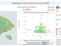
Indonesia ranks as world's second most disaster-prone country, with climate-related losses reaching Rp50 trillion (±USD 3 billion) annually. Over 75,000 villages bear the greatest burden of climate and disaster risks, yet often lack the data needed to allocate climate and disaster budgets effectively. IRID Dashboard, developed by the Ministry of Finance, integrates climate risk indices, village budgets, and fiscal transfers into one free, map-based platform. Users can filter and analyze data…
Innovation Tag: Geolocation and Mapping
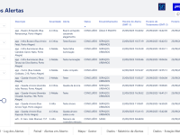
Conecta is a platform that allows public administrators to use technology to anticipate problems faced by cities during extreme weather events, such as flooding, landslides, accidents, and fallen trees. The platform integrates and unifies real-time alerts from different technological sources, enabling faster decision-making and more effective emergency response. Additionally, all the data generated and compiled will allow society to understand new reality and measure how efficiently public…
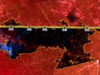
Wildfires is one of the main causes of blackouts in Brazil. To monitor the thousands of Brazilian Transmission Lines (TLs), ANEEL created the GGT System, which consists of a tool that uses Artificial Intelligence and satellite images processing to preventively inspect the maintenance of TLs against wildfires. With the GGT System, there was a 89% reduction in shutdowns caused by wildfires, representing a great improvement in the reliability of the electricity offered to the Brazilian population.
vCity is a human-centric platform for urban digital twins, with the goal of improving life quality within the city by assisting urban planners make evidence-driven urban decisions. vCity's innovative approach combines 1) simulation by designing virtual replicas of the cities, 2) what-if scenario tools in urban planning and 3) getting the "pulse" of the city from digital platforms for citizen participation.
The Ministry of Environment, Water, and Agriculture in Saudi Arabia proudly introduces the innovative mobile application called Livestock Chain as a groundbreaking solution leveraging Blockchain technology to effectively manage livestock data within the all country regions. This visionary application is designed to preserve the rich heritage of livestock while offering a secure mechanism for data storage and retrieval, by assigning each livestock a unique identifier.
Baia Mare has developed a community-driven approach to decontaminate heavy metal-polluted land using plants, addressing a critical public health issue. The project combines phytoremediation, smart mapping technology, and a digital reward system to encourage environmental action and sustainable development. This innovative model empowers citizens, improves urban health, and creates new green economic opportunities.
The SMART LIDAR System uses advanced scanning lidar technology to monitor air quality in real-time and detect pollutants accurately. It helps identify and enforce against illegal emissions, reducing environmental pollution. Affordable and scalable, it offers an innovative solution for air quality monitoring.
Rainlevelr is a joint approach to reduce the risk of flooding. By utilizing the water basins of horticultural companies, the Delfland horticultural area can absorb heavier downpours, thus preventing flooding for both the businesses and the surrounding area. In Rainlevelr, regional authorities, ‘Glastuinbouw Nederland’ and horticultural companies collaborate closely. The uniqueness of this innovation lies in the collaboration among various stakeholders involved in the use of water buffers…
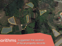
BUPi, is a one-stop shop, developed to integrate different sources of information about property ownership and land management, gathering knowledge on the, until now, unknown land areas and sharing this knowledge with several government agencies in order to create economic and social value for citizens and for the country. BUPi ensures a simple and digital solution that citizens can use to identify and geo-reference their properties, according to the once-only principle.

Marea Digital allows citizens to report local problems to the government, as well as local initiatives that are working for the communities’ well-being. Contrary to similar kind of initiatives, it’s innovative because it uses tech to allow the citizens to aggregate data about their communities’ problems, but also includes an offline strategy for the local government to design solutions with the citizens to solve the problems reported, fostering dialogue and collaboration to solve…