
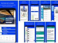
Madrid Móvil is Madrid City Council's commitment to bringing citizens closer to and facilitating their use of and access to municipal services and interaction with the Administration through an app. Madrid Móvil is a one-stop shop through which citizens can carry out all their administrative procedures, request services in sports centres, workshops and cultural activities, as well as communicate warnings and incidents related to city services. The application has achieved 1 million warnings…
Innovation Tag: Geolocation and Mapping
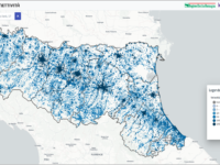
Emilia-Romagna’s Digital Agenda led a significant innovation process for public administration decision-making. The process resulted in a co-design phase with local administrations to structure and publish online the first geo-referenced regional Observatory on ultra-broadband connectivity in Italy. Multi-stakeholder participation made it possible to identify and highlight the various strengths and weaknesses of the tool, enabling its optimisation.
Explore.Porto challenges citizens and visitors to discover and explore the city. The service is provided through a digital platform, anchored in beacons placed in strategic points in Porto. Anyone equipped with a smartphone can instantly obtain information about where they are and their surroundings, as well as the best way to get around. This user-centered innovation has proven its impact on the adoption of local services by both citizens and visitors.
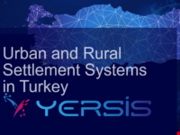
Socioeconomic relations of all levels of settlements are examined with big data at the scale of the smallest settlements to the metropolitans (81 provinces, 973 districts and 37.036 rural units) in Türkiye. The attributes, needs and comparative advantages of each of the settlements analyzed in YER-SIS with an innovative methodology will enable evidence-based national and regional development policies. Public and private sectors, universities, and NGOs are primarily users benefiting from…
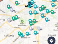
The "EXTREMA Global" application aims at the personalized risk assessment of thermal stresses. Specifically, it is a smartphone application that uses weather data for a specific geographic location and provides personalized information to city residents and visitors about heat-related health threats. Athens was the first city in Greece to use this application.
IQed (Inquiries/Questions in education) utilizes cutting-edge Democratic Technology in classrooms for the purpose of empowering students and educators in Digital Literacy, Civic Literacy, Dynamic Engagement, Critical Thinking/Problem-Solving Skills and Global Competency Education. IQed enables every student to use their personal devices to explore, investigate and become informed on issues of governance and global matters, so that their voice can positively impact local and global communities.
Satellites collect images that can be used to identify deformations of infrastructure at millimetre level with InSAR analysis. This project investigates the use of InSAR in the monitoring of deformations of bridges. Can InSAR be of added value for a structural health assessment of bridges which, with aging assets over the largest part of Europe, becomes more and more critical? Nowadays the monitoring of bridges is very labour intensive and often not without danger. InSAR may reduce this.
Case Study
Tertius – An online construction marketplace that easily connects property developers with…
Tertius has resulted in massive productivity gains for the building industry in DC, enabling developers & property owners to book (at a nominal cost) certified third party agency inspections. Outcome: Far more efficient matching of demand & supply for permit inspections, substantially reducing turnaround times. Tertius has driven revenue to the taxpayers, increased regulatory oversight, increased safety in the building community, saving property owners and developers thousands of dollars.

Mapo-gu created a “SOS One-Stop System” for safe bicycle path. Since there are few buildings or facilities on the bicycle path, it is difficult for users to determine their current location. The basic number plate which is installed on the bicycle path shows the path name and location number and also includes a QR image associated with the system. Through the system, people can quickly call for help in the event of an accident.
Most Brazilian metropolises have a transport network operated by a private company which makes it difficult for transport authorities to have a bright view of the public transport functioning. TRANCITY is a public transport monitoring dashboard which integrates different sources of data, such as bus location, ticketing and cameras, providing real time and historical information that supports management, planning and the operation of public transport networks, with data driven evidence.