

"Defensores" is a platform designed to provide public defenders with a tool to register allegations of torture. This project was carried out in partnership with two key actors in the subject: The Ministry of Public Defense (MDP) and the National Mechanism for Prevention against Torture (MNP). Its implementation facilitates the effective and permanent monitoring of torture by public defenders and generates qualified information for different institutions and society in general. It's the first…
Innovation Tag: Geolocation and Mapping
New Zealand has developed the Emergency Caller Location Information (ECLI) Service. The Service enables Public Safety Organisations (PSOs) to receive automatically generated geographical information about the location of a caller when an emergency call is connected to a mobile cellular network, from any mobile device. ECLI saves lives by decreasing the time taken to verify location and reduce the average dispatch time to incidents, with controls in place to protect callers’ personal…
Originally conceived as a planning tool, HeritageMaps.ie is a user-driven, web-based mapviewer focusing on the built, cultural and natural heritage around Ireland and offshore. Its potential for use by the general public was quickly realised and users can now access 700+ up-to-date heritage datasets in map-form, originally provided across many Govt. platforms. HeritageMaps.ie a free ‘one-stop-shop’ for heritage data and acts as a discovery portal, providing direct links to promote research.
The MSIP Observatory is an interactive tool presenting spatial data of the City of Krakow useful for residents, investors, tourists and anyone interested in our city. The map consists of many layers presenting different kinds of information i.e on architecture and urban planning, nature protection and ecology, administration and security, tourism and history of the city. It's interactive and user-friendly and it implements the idea of open government and open data.
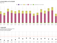
Bogota’s Citizen Complaints Dashboard (Tablero Control Ciudadano) is a preventive and social control web tool that displays the requirements that the citizens put before the public offices. The Citizen Complaints Dashboard gives access to public officials and citizens to the analysis and monitoring of complaints, claims and compliments entered into the System.
The Citizen Complaints Dashboard highlights alerting data related to issues regarding time of attention to the requirements as well as…
Louisville, like many cities, experienced a spike in homicides starting in 2016. Recent deployment of gunshot detection technology has been effective at pinpointing where and when gunshots occur. On average, police officers arrive long after the critical, first ten minute window to stabilize injuries. Placing drones strategically throughout our city, we will be able to deploy a camera to the scene within 90 seconds of when a gun is discharged and rapidly dispatch emergency medical personnel.
The council of the London Borough of Barking and Dagenham is committed to ensuring no residents are "left behind". The population of the borough experiences the highest level of deprivation in the London and has historically struggled with many social and environmental indicators of success. Coupled with central government mandated austerity, the local authority required a strategic decision-making tool to illustrate at a community level where the most investment is needed to improve outcomes.
With the drafting of its first Constitution, Mexico City had a great opportunity: to explore innovative ways of crowd-sourcing this historic document, setting an example to other cities in the world on how to design important democratic experimentation at the scale of a megalopolis. The result of the entire Constitutional process is a forward-thinking document with progressive social policy and human rights at its heart. It became a legal reality in September 2018.
High resolution satellite data were used to make a credible estimate of the number of brick kilns across the ‘Brick Belt’, helping to calculate the scale of modern slavery present. Brick kilns are high slavery-prevalent industries and before this work, the full scale of brick kilns and by proxy, slavery, was unknown, making action from the appropriate agencies difficult. This innovation provides data to help NGOs and governments fight modern slavery. This approach scales in time and space.
Case Study
Development and implementation of an electronic system for animal and plant health surveillance
Animal and plant health surveillance is a part of the structure of agricultural and livestock production, including supply safety, pest and pathogen control, and certification of agro-industrial products. However, we lacked of tools that allow integration of activities and ensure agility in the transmission of the data obtained in the field. We developed an integrated system of surveillance for the inspectors to use, in the animal husbandry agency in the state of Minas Gerais, the Instituto…